gmina Bogatynia
| Bogatynia | |
|---|---|
| Województwo: Voivodeship: | dolnośląskie |
| Powiat: District: | zgorzelecki |
| Gmina: Commune: | Bogatynia |
| Rodzaj gminy: The surface of the area designed for investment: | miejsko-wiejska |
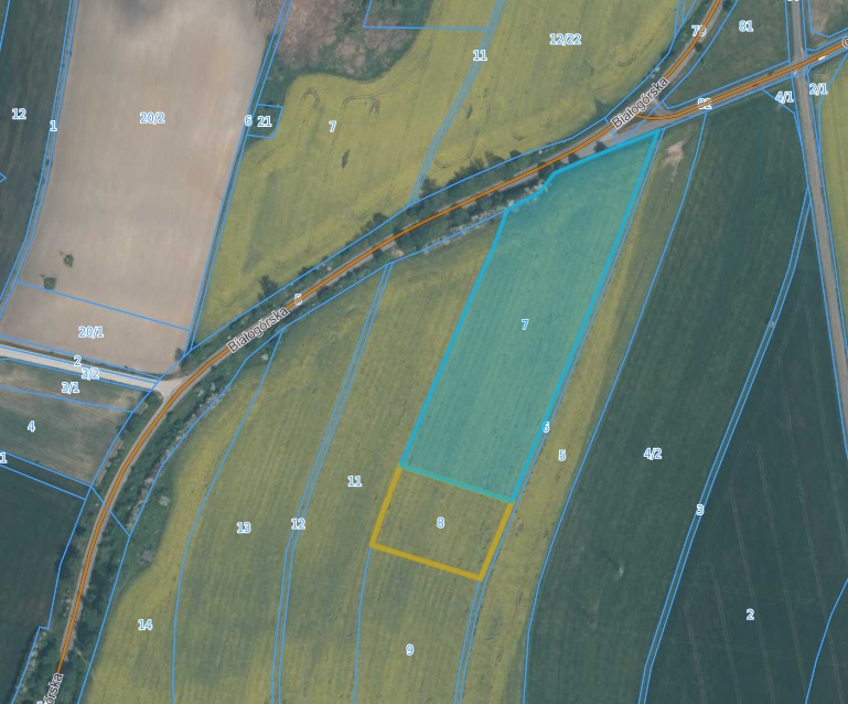
| Powierzchnia terenu przeznaczonego na inwestycję: Number of plot’s precinct: | 11, 5015 |
| Nr obrębu działki: Number of the plot being part of the investment offer: | obręb III Bogatynia |
| Nr działki stanowiącą ofertę inwestycyjną: Number of the plot being part of the investment offer: | 7 |
| Powierzchnia działki: Plot’s surface [ha]: | 3,68 |
| Lokalizacja działki: Plot’s location : | przy ul. Białogórskiej |
| Miejscowy plan zagospodarowania przestrzennego: Local zoning plan: | RADAY MIEJSKIEJ w Bogatyni z dnia 15 września 2015 |
| Odległość sieci wodociągowej: (m) Distance from the plot to the water supply network: [m] | 260 |
| Odległość sieci kanalizacyjnej: (m) Distance from the plot to the sewage system: [m] | 340 |
| Odległość sieci elektroenergetycznej: (m) Distance from the plot to the power network: [m] | 75 |
| Odległość sieci gazowej od działki: (m) Distance from the plot to the gas network: [m] | - |
| Odległość drogi dojazdowej od działki: Distance from the plot to the road: | droga wojewódzka nr 352, droga powiatowa 2361D, (6,12,11-jako droga) |
| Odległość od autostrady/drogi ekspresowej: Distance from the plot to the motorway/ expressway: | 27 KM |
| Czy działka znajduje się na terenie zalewowym: Is the plot at the area of floodplain ? | NIE/NO |
| Klasa bonitacyjna gleby działki: Soil bonitation class of the plot: | R III, R IV |
| Czy działka wymaga odrolnienia: Does the plot require changing the status of farmland ? | NIE/NO |
| Czy teren działki posiada badania geologiczne gruntu: Does the plot’s area have any geological research background ? | NIE/NO |
| Link do dodatkowych informacji: Additional data: | link |
| Uwagi, informacje dodatkowe: Comments: | KOWR - rozpocząć procedurę przejęcia gruntu |
| Link do map: Link to the maps: | |
| Bogatynia | |
|---|---|
| Województwo: Voivodeship: | dolnośląskie |
| Powiat: District: | zgorzelecki |
| Gmina: Commune: | Bogatynia |
| Rodzaj gminy: The surface of the area designed for investment: | miejsko-wiejska |
| Powierzchnia terenu przeznaczonego na inwestycję: Number of plot’s precinct: | 11, 5015 |
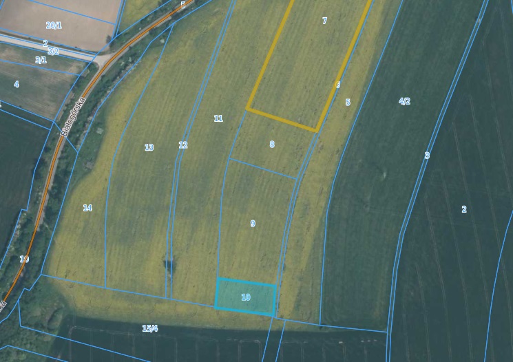
| Nr obrębu działki: Number of the plot being part of the investment offer: | obręb III Bogatynia |
| Nr działki stanowiącą ofertę inwestycyjną: Number of the plot being part of the investment offer: | 8 |
| Powierzchnia działki: Plot’s surface [ha]: | 0,6565 |
| Lokalizacja działki: Plot’s location : | przy ul. Białogórskiej |
| Miejscowy plan zagospodarowania przestrzennego: Local zoning plan: | RADAY MIEJSKIEJ w Bogatyni z dnia 15 września 2015 |
| Odległość sieci wodociągowej: (m) Distance from the plot to the water supply network: [m] | 260 |
| Odległość sieci kanalizacyjnej: (m) Distance from the plot to the sewage system: [m] | 340 |
| Odległość sieci elektroenergetycznej: (m) Distance from the plot to the power network: [m] | 75 |
| Odległość sieci gazowej od działki: (m) Distance from the plot to the gas network: [m] | - |
| Odległość drogi dojazdowej od działki: Distance from the plot to the road: | droga wojewódzka nr 352, droga powiatowa 2361D, (6,12,11-jako droga) |
| Odległość od autostrady/drogi ekspresowej: Distance from the plot to the motorway/ expressway: | 27 KM |
| Czy działka znajduje się na terenie zalewowym: Is the plot at the area of floodplain ? | NIE/NO |
| Klasa bonitacyjna gleby działki: Soil bonitation class of the plot: | R III, R IV |
| Czy działka wymaga odrolnienia: Does the plot require changing the status of farmland ? | NIE/NO |
| Czy teren działki posiada badania geologiczne gruntu: Does the plot’s area have any geological research background ? | NIE/NO |
| Link do dodatkowych informacji: Additional data: | link |
| Uwagi, informacje dodatkowe: Comments: | |
| Link do map: Link to the maps: | |
| Bogatynia | |
|---|---|
| Województwo: Voivodeship: | dolnośląskie |
| Powiat: District: | zgorzelecki |
| Gmina: Commune: | Bogatynia |
| Rodzaj gminy: The surface of the area designed for investment: | miejsko-wiejska |
| Powierzchnia terenu przeznaczonego na inwestycję: Number of plot’s precinct: | 11, 5015 |
| Nr obrębu działki: Number of the plot being part of the investment offer: | obręb III Bogatynia |
| Nr działki stanowiącą ofertę inwestycyjną: Number of the plot being part of the investment offer: | 10 |
| Powierzchnia działki: Plot’s surface [ha]: | 0,5126 |
| Lokalizacja działki: Plot’s location : | przy ul. Białogórskiej |
| Miejscowy plan zagospodarowania przestrzennego: Local zoning plan: | RADAY MIEJSKIEJ w Bogatyni z dnia 15 września 2015 |
| Odległość sieci wodociągowej: (m) Distance from the plot to the water supply network: [m] | 260 |
| Odległość sieci kanalizacyjnej: (m) Distance from the plot to the sewage system: [m] | 340 |
| Odległość sieci elektroenergetycznej: (m) Distance from the plot to the power network: [m] | 75 |
| Odległość sieci gazowej od działki: (m) Distance from the plot to the gas network: [m] | - |
| Odległość drogi dojazdowej od działki: Distance from the plot to the road: | droga wojewódzka nr 352, droga powiatowa 2361D, (6,12,11-jako droga) |
| Odległość od autostrady/drogi ekspresowej: Distance from the plot to the motorway/ expressway: | 27 KM |
| Czy działka znajduje się na terenie zalewowym: Is the plot at the area of floodplain ? | NIE/NO |
| Klasa bonitacyjna gleby działki: Soil bonitation class of the plot: | R III, R IV |
| Czy działka wymaga odrolnienia: Does the plot require changing the status of farmland ? | NIE/NO |
| Czy teren działki posiada badania geologiczne gruntu: Does the plot’s area have any geological research background ? | NIE/NO |
| Link do dodatkowych informacji: Additional data: | link |
| Uwagi, informacje dodatkowe: Comments: | |
| Link do map: Link to the maps: | |
| Bogatynia | |
|---|---|
| Województwo: Voivodeship: | dolnośląskie |
| Powiat: District: | zgorzelecki |
| Gmina: Commune: | Bogatynia |
| Rodzaj gminy: The surface of the area designed for investment: | miejsko-wiejska |
| Powierzchnia terenu przeznaczonego na inwestycję: Number of plot’s precinct: | '7, 1580 |
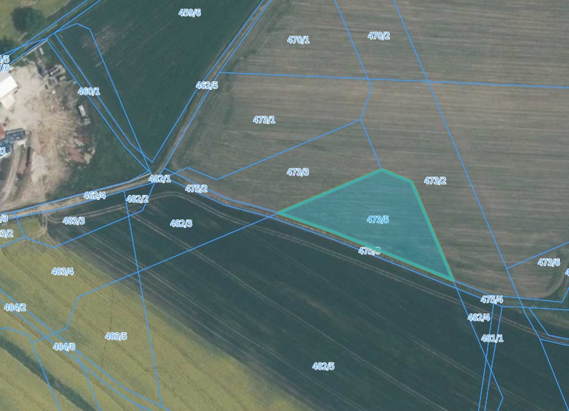
| Nr obrębu działki: Number of the plot being part of the investment offer: | obręb Porajów |
| Nr działki stanowiącą ofertę inwestycyjną: Number of the plot being part of the investment offer: | 473/5 |
| Powierzchnia działki: Plot’s surface [ha]: | 0,2663 |
| Lokalizacja działki: Plot’s location : | Porajów |
| Miejscowy plan zagospodarowania przestrzennego: Local zoning plan: | RADY MIEJSKIEJ w Bogatyni z dnia 15 września 2015 |
| Odległość sieci wodociągowej: (m) Distance from the plot to the water supply network: [m] | 60 |
| Odległość sieci kanalizacyjnej: (m) Distance from the plot to the sewage system: [m] | 10 |
| Odległość sieci elektroenergetycznej: (m) Distance from the plot to the power network: [m] | 10 |
| Odległość sieci gazowej od działki: (m) Distance from the plot to the gas network: [m] | - |
| Odległość drogi dojazdowej od działki: Distance from the plot to the road: | droga wojewódzka nr 352 |
| Odległość od autostrady/drogi ekspresowej: Distance from the plot to the motorway/ expressway: | 38KM |
| Czy działka znajduje się na terenie zalewowym: Is the plot at the area of floodplain ? | NIE/NO |
| Klasa bonitacyjna gleby działki: Soil bonitation class of the plot: | RII, RIII, R IV |
| Czy działka wymaga odrolnienia: Does the plot require changing the status of farmland ? | TAK/YES |
| Czy teren działki posiada badania geologiczne gruntu: Does the plot’s area have any geological research background ? | NIE/NO |
| Link do dodatkowych informacji: Additional data: | link |
| Uwagi, informacje dodatkowe: Comments: | |
| Link do map: Link to the maps: | |
| Bogatynia | |
|---|---|
| Województwo: Voivodeship: | dolnośląskie |
| Powiat: District: | zgorzelecki |
| Gmina: Commune: | Bogatynia |
| Rodzaj gminy: The surface of the area designed for investment: | miejsko-wiejska |
| Powierzchnia terenu przeznaczonego na inwestycję: Number of plot’s precinct: | '7, 1581 |
| Nr obrębu działki: Number of the plot being part of the investment offer: | obręb Porajów |
| Nr działki stanowiącą ofertę inwestycyjną: Number of the plot being part of the investment offer: | 475/3 |
| Powierzchnia działki: Plot’s surface [ha]: | 0,2536 |
| Lokalizacja działki: Plot’s location : | Porajów |
| Miejscowy plan zagospodarowania przestrzennego: Local zoning plan: | RADY MIEJSKIEJ w Bogatyni z dnia 15 września 2015 |
| Odległość sieci wodociągowej: (m) Distance from the plot to the water supply network: [m] | 60 |
| Odległość sieci kanalizacyjnej: (m) Distance from the plot to the sewage system: [m] | 10 |
| Odległość sieci elektroenergetycznej: (m) Distance from the plot to the power network: [m] | 10 |
| Odległość sieci gazowej od działki: (m) Distance from the plot to the gas network: [m] | - |
| Odległość drogi dojazdowej od działki: Distance from the plot to the road: | droga wojewódzka nr 352 |
| Odległość od autostrady/drogi ekspresowej: Distance from the plot to the motorway/ expressway: | 38KM |
| Czy działka znajduje się na terenie zalewowym: Is the plot at the area of floodplain ? | NIE/NO |
| Klasa bonitacyjna gleby działki: Soil bonitation class of the plot: | RII, RIII, R IV |
| Czy działka wymaga odrolnienia: Does the plot require changing the status of farmland ? | TAK/YES |
| Czy teren działki posiada badania geologiczne gruntu: Does the plot’s area have any geological research background ? | NIE/NO |
| Link do dodatkowych informacji: Additional data: | link |
| Uwagi, informacje dodatkowe: Comments: | |
| Link do map: Link to the maps: | |
| Bogatynia | |
|---|---|
| Województwo: Voivodeship: | dolnośląskie |
| Powiat: District: | zgorzelecki |
| Gmina: Commune: | Bogatynia |
| Rodzaj gminy: The surface of the area designed for investment: | miejsko-wiejska |
| Powierzchnia terenu przeznaczonego na inwestycję: Number of plot’s precinct: | '7, 1581 |
| Nr obrębu działki: Number of the plot being part of the investment offer: | obręb Porajów |
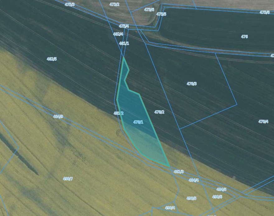
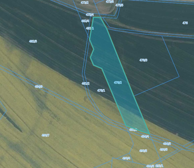
| Nr działki stanowiącą ofertę inwestycyjną: Number of the plot being part of the investment offer: | 478/1 |
| Powierzchnia działki: Plot’s surface [ha]: | 0,3105 |
| Lokalizacja działki: Plot’s location : | Porajów |
| Miejscowy plan zagospodarowania przestrzennego: Local zoning plan: | RADY MIEJSKIEJ w Bogatyni z dnia 15 września 2015 |
| Odległość sieci wodociągowej: (m) Distance from the plot to the water supply network: [m] | 60 |
| Odległość sieci kanalizacyjnej: (m) Distance from the plot to the sewage system: [m] | 10 |
| Odległość sieci elektroenergetycznej: (m) Distance from the plot to the power network: [m] | 10 |
| Odległość sieci gazowej od działki: (m) Distance from the plot to the gas network: [m] | - |
| Odległość drogi dojazdowej od działki: Distance from the plot to the road: | droga wojewódzka nr 352 |
| Odległość od autostrady/drogi ekspresowej: Distance from the plot to the motorway/ expressway: | 38KM |
| Czy działka znajduje się na terenie zalewowym: Is the plot at the area of floodplain ? | NIE/NO |
| Klasa bonitacyjna gleby działki: Soil bonitation class of the plot: | RII, RIII, R IV |
| Czy działka wymaga odrolnienia: Does the plot require changing the status of farmland ? | TAK/YES |
| Czy teren działki posiada badania geologiczne gruntu: Does the plot’s area have any geological research background ? | NIE/NO |
| Link do dodatkowych informacji: Additional data: | link |
| Uwagi, informacje dodatkowe: Comments: | |
| Link do map: Link to the maps: | |
| Bogatynia | |
|---|---|
| Województwo: Voivodeship: | dolnośląskie |
| Powiat: District: | zgorzelecki |
| Gmina: Commune: | Bogatynia |
| Rodzaj gminy: The surface of the area designed for investment: | miejsko-wiejska |
| Powierzchnia terenu przeznaczonego na inwestycję: Number of plot’s precinct: | '7, 1581 |
| Nr obrębu działki: Number of the plot being part of the investment offer: | obręb Porajów |
| Nr działki stanowiącą ofertę inwestycyjną: Number of the plot being part of the investment offer: | 478/2 |
| Powierzchnia działki: Plot’s surface [ha]: | 2,3768 |
| Lokalizacja działki: Plot’s location : | Porajów |
| Miejscowy plan zagospodarowania przestrzennego: Local zoning plan: | RADY MIEJSKIEJ w Bogatyni z dnia 15 września 2015 |
| Odległość sieci wodociągowej: (m) Distance from the plot to the water supply network: [m] | 60 |
| Odległość sieci kanalizacyjnej: (m) Distance from the plot to the sewage system: [m] | 10 |
| Odległość sieci elektroenergetycznej: (m) Distance from the plot to the power network: [m] | 10 |
| Odległość sieci gazowej od działki: (m) Distance from the plot to the gas network: [m] | - |
| Odległość drogi dojazdowej od działki: Distance from the plot to the road: | droga wojewódzka nr 352 |
| Odległość od autostrady/drogi ekspresowej: Distance from the plot to the motorway/ expressway: | 38KM |
| Czy działka znajduje się na terenie zalewowym: Is the plot at the area of floodplain ? | NIE/NO |
| Klasa bonitacyjna gleby działki: Soil bonitation class of the plot: | RII, RIII, R IV |
| Czy działka wymaga odrolnienia: Does the plot require changing the status of farmland ? | TAK/YES |
| Czy teren działki posiada badania geologiczne gruntu: Does the plot’s area have any geological research background ? | NIE/NO |
| Link do dodatkowych informacji: Additional data: | link |
| Uwagi, informacje dodatkowe: Comments: | |
| Link do map: Link to the maps: | |
| Bogatynia | |
|---|---|
| Województwo: Voivodeship: | dolnośląskie |
| Powiat: District: | zgorzelecki |
| Gmina: Commune: | Bogatynia |
| Rodzaj gminy: The surface of the area designed for investment: | miejsko-wiejska |
| Powierzchnia terenu przeznaczonego na inwestycję: Number of plot’s precinct: | '7, 1581 |
| Nr obrębu działki: Number of the plot being part of the investment offer: | obręb Porajów |
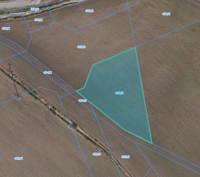
| Nr działki stanowiącą ofertę inwestycyjną: Number of the plot being part of the investment offer: | 483/5 |
| Powierzchnia działki: Plot’s surface [ha]: | 0,232 |
| Lokalizacja działki: Plot’s location : | Porajów |
| Miejscowy plan zagospodarowania przestrzennego: Local zoning plan: | RADY MIEJSKIEJ w Bogatyni z dnia 15 września 2015 |
| Odległość sieci wodociągowej: (m) Distance from the plot to the water supply network: [m] | 60 |
| Odległość sieci kanalizacyjnej: (m) Distance from the plot to the sewage system: [m] | 10 |
| Odległość sieci elektroenergetycznej: (m) Distance from the plot to the power network: [m] | 10 |
| Odległość sieci gazowej od działki: (m) Distance from the plot to the gas network: [m] | - |
| Odległość drogi dojazdowej od działki: Distance from the plot to the road: | droga wojewódzka nr 352 |
| Odległość od autostrady/drogi ekspresowej: Distance from the plot to the motorway/ expressway: | 38KM |
| Czy działka znajduje się na terenie zalewowym: Is the plot at the area of floodplain ? | NIE/NO |
| Klasa bonitacyjna gleby działki: Soil bonitation class of the plot: | RII, RIII, R IV |
| Czy działka wymaga odrolnienia: Does the plot require changing the status of farmland ? | TAK/YES |
| Czy teren działki posiada badania geologiczne gruntu: Does the plot’s area have any geological research background ? | NIE/NO |
| Link do dodatkowych informacji: Additional data: | link |
| Uwagi, informacje dodatkowe: Comments: | |
| Link do map: Link to the maps: | |
| Bogatynia | |
|---|---|
| Województwo: Voivodeship: | dolnośląskie |
| Powiat: District: | zgorzelecki |
| Gmina: Commune: | Bogatynia |
| Rodzaj gminy: The surface of the area designed for investment: | miejsko-wiejska |
| Powierzchnia terenu przeznaczonego na inwestycję: Number of plot’s precinct: | '7, 1581 |
| Nr obrębu działki: Number of the plot being part of the investment offer: | obręb Porajów |
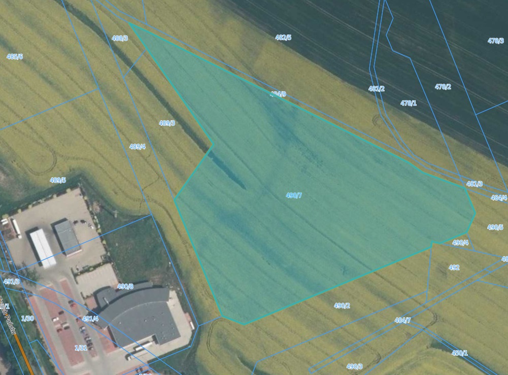
| Nr działki stanowiącą ofertę inwestycyjną: Number of the plot being part of the investment offer: | 490/7 |
| Powierzchnia działki: Plot’s surface [ha]: | 2,6418 |
| Lokalizacja działki: Plot’s location : | Porajów |
| Miejscowy plan zagospodarowania przestrzennego: Local zoning plan: | RADY MIEJSKIEJ w Bogatyni z dnia 15 września 2015 |
| Odległość sieci wodociągowej: (m) Distance from the plot to the water supply network: [m] | 60 |
| Odległość sieci kanalizacyjnej: (m) Distance from the plot to the sewage system: [m] | 10 |
| Odległość sieci elektroenergetycznej: (m) Distance from the plot to the power network: [m] | 10 |
| Odległość sieci gazowej od działki: (m) Distance from the plot to the gas network: [m] | - |
| Odległość drogi dojazdowej od działki: Distance from the plot to the road: | droga wojewódzka nr 352 |
| Odległość od autostrady/drogi ekspresowej: Distance from the plot to the motorway/ expressway: | 38KM |
| Czy działka znajduje się na terenie zalewowym: Is the plot at the area of floodplain ? | NIE/NO |
| Klasa bonitacyjna gleby działki: Soil bonitation class of the plot: | RII, RIII, R IV |
| Czy działka wymaga odrolnienia: Does the plot require changing the status of farmland ? | TAK/YES |
| Czy teren działki posiada badania geologiczne gruntu: Does the plot’s area have any geological research background ? | NIE/NO |
| Link do dodatkowych informacji: Additional data: | link |
| Uwagi, informacje dodatkowe: Comments: | |
| Link do map: Link to the maps: | |
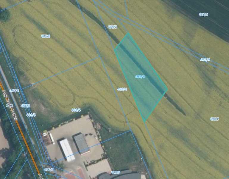
| Bogatynia | |
|---|---|
| Województwo: Voivodeship: | dolnośląskie |
| Powiat: District: | zgorzelecki |
| Gmina: Commune: | Bogatynia |
| Rodzaj gminy: The surface of the area designed for investment: | miejsko-wiejska |
| Powierzchnia terenu przeznaczonego na inwestycję: Number of plot’s precinct: | '7, 1581 |
| Nr obrębu działki: Number of the plot being part of the investment offer: | obręb Porajów |
| Nr działki stanowiącą ofertę inwestycyjną: Number of the plot being part of the investment offer: | 489/3 |
| Powierzchnia działki: Plot’s surface [ha]: | 0,3338 |
| Lokalizacja działki: Plot’s location : | Porajów |
| Miejscowy plan zagospodarowania przestrzennego: Local zoning plan: | RADY MIEJSKIEJ w Bogatyni z dnia 15 września 2015 |
| Odległość sieci wodociągowej: (m) Distance from the plot to the water supply network: [m] | 60 |
| Odległość sieci kanalizacyjnej: (m) Distance from the plot to the sewage system: [m] | 10 |
| Odległość sieci elektroenergetycznej: (m) Distance from the plot to the power network: [m] | 10 |
| Odległość sieci gazowej od działki: (m) Distance from the plot to the gas network: [m] | - |
| Odległość drogi dojazdowej od działki: Distance from the plot to the road: | droga wojewódzka nr 352 |
| Odległość od autostrady/drogi ekspresowej: Distance from the plot to the motorway/ expressway: | 38KM |
| Czy działka znajduje się na terenie zalewowym: Is the plot at the area of floodplain ? | NIE/NO |
| Klasa bonitacyjna gleby działki: Soil bonitation class of the plot: | RII, RIII, R IV |
| Czy działka wymaga odrolnienia: Does the plot require changing the status of farmland ? | TAK/YES |
| Czy teren działki posiada badania geologiczne gruntu: Does the plot’s area have any geological research background ? | NIE/NO |
| Link do dodatkowych informacji: Additional data: | link |
| Uwagi, informacje dodatkowe: Comments: | |
| Link do map: Link to the maps: | |