gmina Zgorzelec
| Zgorzelec | |
|---|---|
| Województwo: Voivodeship: | dolnośląskie |
| Powiat: District: | zgorzelecki |
| Gmina: Commune: | Zgorzelec |
| Rodzaj gminy: The surface of the area designed for investment: | wiejska |
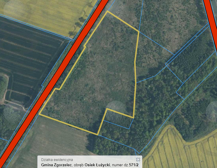
| Powierzchnia terenu przeznaczonego na inwestycję: Number of plot’s precinct: | 4,8 |
| Nr obrębu działki: Number of the plot being part of the investment offer: | XIII |
| Nr działki stanowiącą ofertę inwestycyjną: Number of the plot being part of the investment offer: | 571/2 |
| Powierzchnia działki: Plot’s surface [ha]: | 4,8 |
| Lokalizacja działki: Plot’s location : | Osiek Łużycki |
| Miejscowy plan zagospodarowania przestrzennego: Local zoning plan: | UCHWAŁA Nr 170/2009, RADY GMINY ZGORZELEC, z dnia 16 lutego 2009 roku |
| Odległość sieci wodociągowej: (m) Distance from the plot to the water supply network: [m] | - |
| Odległość sieci kanalizacyjnej: (m) Distance from the plot to the sewage system: [m] | - |
| Odległość sieci elektroenergetycznej: (m) Distance from the plot to the power network: [m] | 0 |
| Odległość sieci gazowej od działki: (m) Distance from the plot to the gas network: [m] | - |
| Odległość drogi dojazdowej od działki: Distance from the plot to the road: | bezpośrednie położenie przy DW nr 352 |
| Odległość od autostrady/drogi ekspresowej: Distance from the plot to the motorway/ expressway: | 13,5 km od A4 |
| Czy działka znajduje się na terenie zalewowym: Is the plot at the area of floodplain ? | - |
| Klasa bonitacyjna gleby działki: Soil bonitation class of the plot: | RIVa/RV |
| Czy działka wymaga odrolnienia: Does the plot require changing the status of farmland ? | - |
| Czy teren działki posiada badania geologiczne gruntu: Does the plot’s area have any geological research background ? | - |
| Link do dodatkowych informacji: Additional data: | - |
| Uwagi, informacje dodatkowe: Comments: | - |
| Link do map: Link to the maps: | link |
| Zgorzelec | |
|---|---|
| Województwo: Voivodeship: | dolnośląskie |
| Powiat: District: | zgorzelecki |
| Gmina: Commune: | Zgorzelec |
| Rodzaj gminy: The surface of the area designed for investment: | wiejska |
| Powierzchnia terenu przeznaczonego na inwestycję: Number of plot’s precinct: | 0,84 |
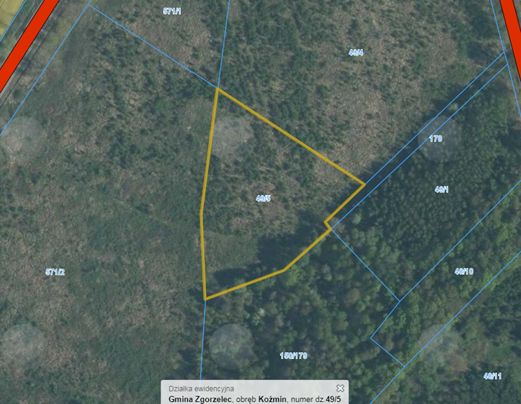
| Nr obrębu działki: Number of the plot being part of the investment offer: | VIII |
| Nr działki stanowiącą ofertę inwestycyjną: Number of the plot being part of the investment offer: | 49/5 |
| Powierzchnia działki: Plot’s surface [ha]: | 0,84 |
| Lokalizacja działki: Plot’s location : | Koźmin |
| Miejscowy plan zagospodarowania przestrzennego: Local zoning plan: | UCHWAŁA Nr 170/2009, RADY GMINY ZGORZELEC, z dnia 16 lutego 2009 roku |
| Odległość sieci wodociągowej: (m) Distance from the plot to the water supply network: [m] | - |
| Odległość sieci kanalizacyjnej: (m) Distance from the plot to the sewage system: [m] | - |
| Odległość sieci elektroenergetycznej: (m) Distance from the plot to the power network: [m] | 1 |
| Odległość sieci gazowej od działki: (m) Distance from the plot to the gas network: [m] | - |
| Odległość drogi dojazdowej od działki: Distance from the plot to the road: | bezpośrednie położenie przy DW nr 352 |
| Odległość od autostrady/drogi ekspresowej: Distance from the plot to the motorway/ expressway: | 13,5 km od A4 |
| Czy działka znajduje się na terenie zalewowym: Is the plot at the area of floodplain ? | NIE/NO |
| Klasa bonitacyjna gleby działki: Soil bonitation class of the plot: | RV |
| Czy działka wymaga odrolnienia: Does the plot require changing the status of farmland ? | - |
| Czy teren działki posiada badania geologiczne gruntu: Does the plot’s area have any geological research background ? | - |
| Link do dodatkowych informacji: Additional data: | - |
| Uwagi, informacje dodatkowe: Comments: | - |
| Link do map: Link to the maps: | link |

| Zgorzelec | |
|---|---|
| Województwo: Voivodeship: | dolnośląskie |
| Powiat: District: | zgorzelecki |
| Gmina: Commune: | Zgorzelec |
| Rodzaj gminy: The surface of the area designed for investment: | wiejska |
| Powierzchnia terenu przeznaczonego na inwestycję: Number of plot’s precinct: | 0,93 |
| Nr obrębu działki: Number of the plot being part of the investment offer: | VIII |
| Nr działki stanowiącą ofertę inwestycyjną: Number of the plot being part of the investment offer: | 49/7 |
| Powierzchnia działki: Plot’s surface [ha]: | 0,93 |
| Lokalizacja działki: Plot’s location : | Koźmin |
| Miejscowy plan zagospodarowania przestrzennego: Local zoning plan: | UCHWAŁA Nr 170/2009, RADY GMINY ZGORZELEC, z dnia 16 lutego 2009 roku |
| Odległość sieci wodociągowej: (m) Distance from the plot to the water supply network: [m] | - |
| Odległość sieci kanalizacyjnej: (m) Distance from the plot to the sewage system: [m] | - |
| Odległość sieci elektroenergetycznej: (m) Distance from the plot to the power network: [m] | 1 |
| Odległość sieci gazowej od działki: (m) Distance from the plot to the gas network: [m] | - |
| Odległość drogi dojazdowej od działki: Distance from the plot to the road: | bezpośrednie położenie przy DW nr 352 |
| Odległość od autostrady/drogi ekspresowej: Distance from the plot to the motorway/ expressway: | 13,5 km od A4 |
| Czy działka znajduje się na terenie zalewowym: Is the plot at the area of floodplain ? | NIE/NO |
| Klasa bonitacyjna gleby działki: Soil bonitation class of the plot: | RV |
| Czy działka wymaga odrolnienia: Does the plot require changing the status of farmland ? | - |
| Czy teren działki posiada badania geologiczne gruntu: Does the plot’s area have any geological research background ? | - |
| Link do dodatkowych informacji: Additional data: | - |
| Uwagi, informacje dodatkowe: Comments: | - |
| Link do map: Link to the maps: | link |