gmina Lubomierz
| Lubomierz | |
|---|---|
| Województwo: Voivodeship: | dolnośląskie |
| Powiat: District: | lwówecki |
| Gmina: Commune: | Lubomierz |
| Rodzaj gminy: The surface of the area designed for investment: | Miejsko-wiejska |
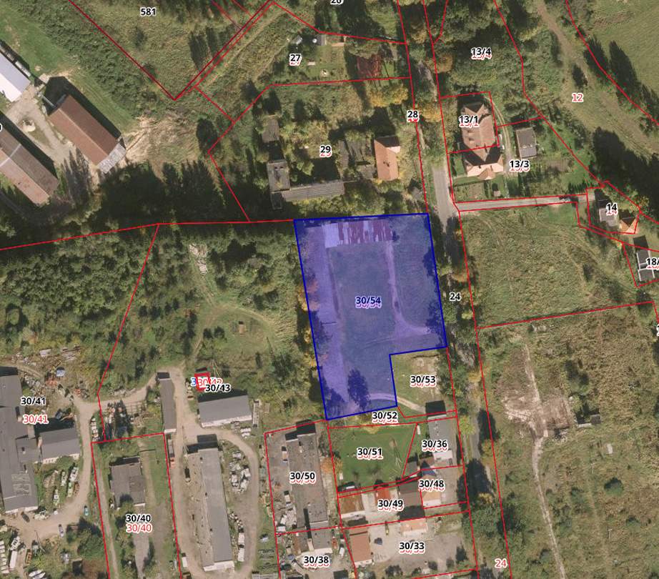
| Powierzchnia terenu przeznaczonego na inwestycję: Number of plot’s precinct: | 7,1987 |
| Nr obrębu działki: Number of the plot being part of the investment offer: | 0002 Lubomierz II |
| Nr działki stanowiącą ofertę inwestycyjną: Number of the plot being part of the investment offer: | 30/54 |
| Powierzchnia działki: Plot’s surface [ha]: | 0,5723 |
| Lokalizacja działki: Plot’s location : | miasto Lubomierz |
| Miejscowy plan zagospodarowania przestrzennego: Local zoning plan: | TAK/YES |
| Odległość sieci wodociągowej: (m) Distance from the plot to the water supply network: [m] | 1035 |
| Odległość sieci kanalizacyjnej: (m) Distance from the plot to the sewage system: [m] | 1035 |
| Odległość sieci elektroenergetycznej: (m) Distance from the plot to the power network: [m] | 10 |
| Odległość sieci gazowej od działki: (m) Distance from the plot to the gas network: [m] | NIE/NO |
| Odległość drogi dojazdowej od działki: Distance from the plot to the road: | 15 m |
| Odległość od autostrady/drogi ekspresowej: Distance from the plot to the motorway/ expressway: | 4 km |
| Czy działka znajduje się na terenie zalewowym: Is the plot at the area of floodplain ? | NIE/NO |
| Klasa bonitacyjna gleby działki: Soil bonitation class of the plot: | Bi |
| Czy działka wymaga odrolnienia: Does the plot require changing the status of farmland ? | NIE/NO |
| Czy teren działki posiada badania geologiczne gruntu: Does the plot’s area have any geological research background ? | NIE/NO |
| Link do dodatkowych informacji: Additional data: | link |
| Uwagi, informacje dodatkowe: Comments: | - |
| Link do map: Link to the maps: | link |
| Lubomierz | |
|---|---|
| Województwo: Voivodeship: | dolnośląskie |
| Powiat: District: | lwówecki |
| Gmina: Commune: | Lubomierz |
| Rodzaj gminy: The surface of the area designed for investment: | Miejsko-wiejska |
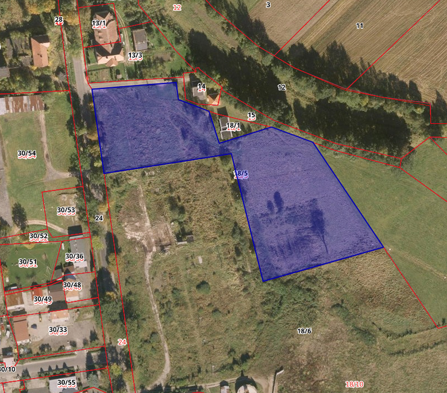
| Powierzchnia terenu przeznaczonego na inwestycję: Number of plot’s precinct: | 7,1987 |
| Nr obrębu działki: Number of the plot being part of the investment offer: | 0002 Lubomierz II |
| Nr działki stanowiącą ofertę inwestycyjną: Number of the plot being part of the investment offer: | 18/5 |
| Powierzchnia działki: Plot’s surface [ha]: | 1,1302 |
| Lokalizacja działki: Plot’s location : | miasto Lubomierz |
| Miejscowy plan zagospodarowania przestrzennego: Local zoning plan: | TAK/YES |
| Odległość sieci wodociągowej: (m) Distance from the plot to the water supply network: [m] | 1136 |
| Odległość sieci kanalizacyjnej: (m) Distance from the plot to the sewage system: [m] | 1136 |
| Odległość sieci elektroenergetycznej: (m) Distance from the plot to the power network: [m] | 0 |
| Odległość sieci gazowej od działki: (m) Distance from the plot to the gas network: [m] | NIE/NO |
| Odległość drogi dojazdowej od działki: Distance from the plot to the road: | 5 m |
| Odległość od autostrady/drogi ekspresowej: Distance from the plot to the motorway/ expressway: | 4 km |
| Czy działka znajduje się na terenie zalewowym: Is the plot at the area of floodplain ? | NIE/NO |
| Klasa bonitacyjna gleby działki: Soil bonitation class of the plot: | Bi |
| Czy działka wymaga odrolnienia: Does the plot require changing the status of farmland ? | NIE/NO |
| Czy teren działki posiada badania geologiczne gruntu: Does the plot’s area have any geological research background ? | NIE/NO |
| Link do dodatkowych informacji: Additional data: | link |
| Uwagi, informacje dodatkowe: Comments: | - |
| Link do map: Link to the maps: | link |
| Lubomierz | |
|---|---|
| Województwo: Voivodeship: | dolnośląskie |
| Powiat: District: | lwówecki |
| Gmina: Commune: | Lubomierz |
| Rodzaj gminy: The surface of the area designed for investment: | Miejsko-wiejska |
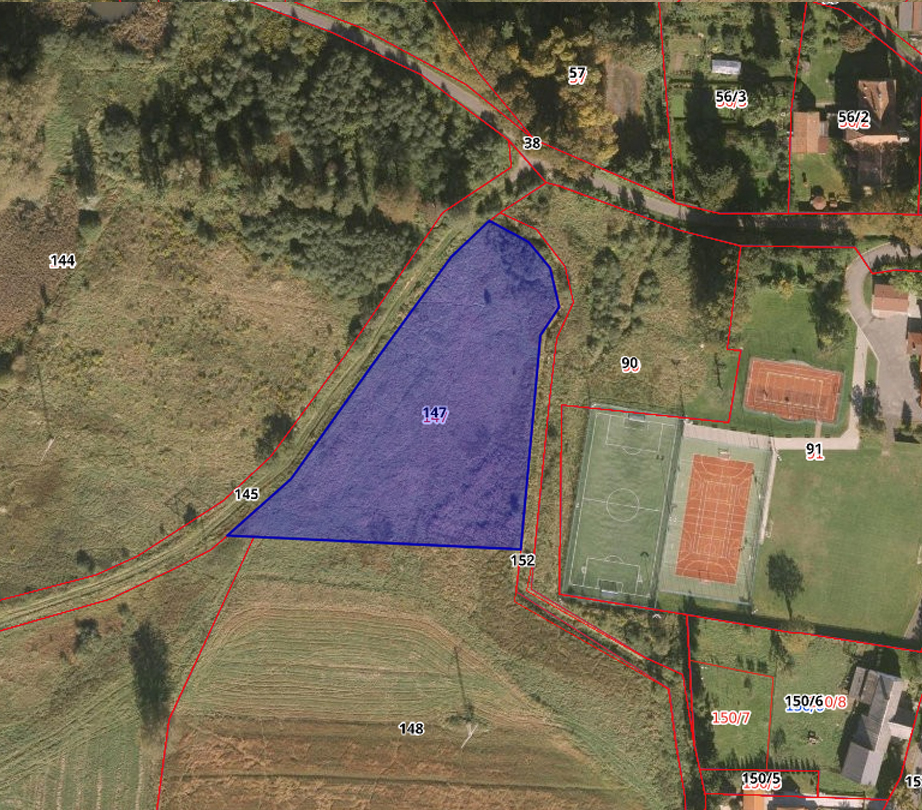
| Powierzchnia terenu przeznaczonego na inwestycję: Number of plot’s precinct: | 7,1987 |
| Nr obrębu działki: Number of the plot being part of the investment offer: | Lubomierz I |
| Nr działki stanowiącą ofertę inwestycyjną: Number of the plot being part of the investment offer: | 147 |
| Powierzchnia działki: Plot’s surface [ha]: | 0,5971 |
| Lokalizacja działki: Plot’s location : | miasto Lubomierz |
| Miejscowy plan zagospodarowania przestrzennego: Local zoning plan: | TAK/YES |
| Odległość sieci wodociągowej: (m) Distance from the plot to the water supply network: [m] | 1000 |
| Odległość sieci kanalizacyjnej: (m) Distance from the plot to the sewage system: [m] | 1000 |
| Odległość sieci elektroenergetycznej: (m) Distance from the plot to the power network: [m] | 100 |
| Odległość sieci gazowej od działki: (m) Distance from the plot to the gas network: [m] | NIE/NO |
| Odległość drogi dojazdowej od działki: Distance from the plot to the road: | 25 m |
| Odległość od autostrady/drogi ekspresowej: Distance from the plot to the motorway/ expressway: | 4 km |
| Czy działka znajduje się na terenie zalewowym: Is the plot at the area of floodplain ? | NIE/NO |
| Klasa bonitacyjna gleby działki: Soil bonitation class of the plot: | R-IVa Ł-IV |
| Czy działka wymaga odrolnienia: Does the plot require changing the status of farmland ? | NIE/NO |
| Czy teren działki posiada badania geologiczne gruntu: Does the plot’s area have any geological research background ? | NIE/NO |
| Link do dodatkowych informacji: Additional data: | link |
| Uwagi, informacje dodatkowe: Comments: | - |
| Link do map: Link to the maps: | link |
| Lubomierz | |
|---|---|
| Województwo: Voivodeship: | dolnośląskie |
| Powiat: District: | lwówecki |
| Gmina: Commune: | Lubomierz |
| Rodzaj gminy: The surface of the area designed for investment: | Miejsko-wiejska |
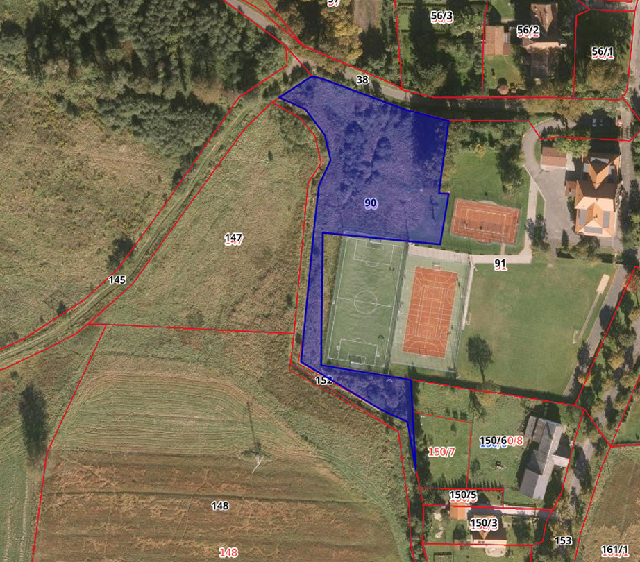
| Powierzchnia terenu przeznaczonego na inwestycję: Number of plot’s precinct: | 7,1987 |
| Nr obrębu działki: Number of the plot being part of the investment offer: | Lubomierz I |
| Nr działki stanowiącą ofertę inwestycyjną: Number of the plot being part of the investment offer: | 90 |
| Powierzchnia działki: Plot’s surface [ha]: | 0,4843 |
| Lokalizacja działki: Plot’s location : | miasto Lubomierz |
| Miejscowy plan zagospodarowania przestrzennego: Local zoning plan: | TAK/YES |
| Odległość sieci wodociągowej: (m) Distance from the plot to the water supply network: [m] | 900 |
| Odległość sieci kanalizacyjnej: (m) Distance from the plot to the sewage system: [m] | 900 |
| Odległość sieci elektroenergetycznej: (m) Distance from the plot to the power network: [m] | 200 |
| Odległość sieci gazowej od działki: (m) Distance from the plot to the gas network: [m] | NIE/NO |
| Odległość drogi dojazdowej od działki: Distance from the plot to the road: | 5 m |
| Odległość od autostrady/drogi ekspresowej: Distance from the plot to the motorway/ expressway: | 4 km |
| Czy działka znajduje się na terenie zalewowym: Is the plot at the area of floodplain ? | NIE/NO |
| Klasa bonitacyjna gleby działki: Soil bonitation class of the plot: | PS IV W |
| Czy działka wymaga odrolnienia: Does the plot require changing the status of farmland ? | NIE/NO |
| Czy teren działki posiada badania geologiczne gruntu: Does the plot’s area have any geological research background ? | NIE/NO |
| Link do dodatkowych informacji: Additional data: | link |
| Uwagi, informacje dodatkowe: Comments: | - |
| Link do map: Link to the maps: | link |